









The turbulent spring could offer a preview of Canada’s upcoming summer, with the transition to El Nino expected to make it hard for hot and dry weather to lock into place over some regions, The Weather Network’s senior meteorologist says.
The exception is Western Canada, where it’s shaping up to be warmer and drier than normal this summer, raising the risk of drought and wildfire.
Rest assured, summer will show up in Central and Eastern Canada, but the heat may be more inconsistent than in recent years, said meteorologist Doug Gillham.
“In terms of locking into a consistently hot, dry pattern … we just don’t expect that to be the theme of the season,” said Gillham.
The Weather Network on Wednesday released its seasonal forecast for the three-month period of June, July and August.
The up-and-down forecast is partly a reflection of a fluctuating global weather pattern, transitioning from La Nina to a potentially historic El Nino. The warming El Nino phase and its opposite La Nina are part of a natural climate cycle tied to shifting patches of warm water in the equatorial Pacific.
“The global pattern is in a state of flux, and that’s why it’s more difficult to lock into a pattern,” said Gillham.
A “huge concern” in the forecast is the risk of wildfire and smoke in Western Canada, especially drought-stricken parts of the British Columbia Interior, Gillham said.
“The ingredients are in place for a concerning wildfire season,” he said.
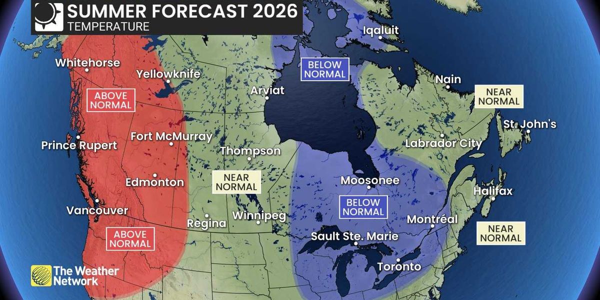
In British Columbia, Gillham says the summer could be significantly warmer than normal, though it doesn’t mean the heat will be relentless or even as severe as some recent years. It also may not stick around deep into September, with the forecast suggesting a more normal transition to fall could be in the works.
Into the Prairies, a sputtering spring has been replaced by summer-like heat this week, a glimpse of how the season is expected to start.
The warmer-than-normal temperatures this summer are expected to be concentrated in the west, across Alberta and into western Saskatchewan. The farther east you go, the more variable it gets, said Gillham.
While summer precipitation can be “very challenging” to forecast, drought is a concern and early season rain will be watched closely, Gillham said. The transition to El Nino conditions could help to drive the Pacific storm track deeper into the United States and deprive some southern parts of the Prairies of early summer rain, Gillham said.
June is typically the wettest month of the year and sets the foundation for the agricultural regions. The forecast suggests much of the Prairies is set to be drier than normal, especially for the first half of the summer.
Moving east, the warm start to the season could spread into northern Ontario. That won’t last though, with all of the province likely to tip to the cool side of normal come July and August.
“It does not mean summer’s cancelled,” said Gillham. “We will see periods where summer definitely shows up, but we won’t lock into a persistent hot pattern.”
Frequent threats for showers and thunderstorms will also keep southern and eastern Ontario well watered, with above-normal precipitation expected in those areas.
It’s a similar story for Quebec, where periods of hot weather will be offset by more comfortable, “refreshing” weather and a more frequent threat of showers and thunderstorms across western and southern parts of the province, Gillham said.
A back-and-forth swing in temperatures will likely bring most of Atlantic Canada to near-normal temperatures for the season.
A drier-than-normal summer is expected across parts of Western Canada, while above-normal precipitation is expected through parts of Eastern Canada, as shown in this 2026 summer forecast map provided by The Weather Network.
THE CANADIAN PRESS/Handout – The Weather Network (Mandatory Credit)
Showers and thunderstorms should be more plentiful this season too, with the Maritimes expected to see above-normal precipitation. Newfoundland and Labrador will wind up closer to normal on the season.
“It doesn’t mean it’s going to rain on a daily basis. But for agriculture and for the wildfire risk and air quality, it is good news; less concern about drought this summer,” Gillham said.
Hurricane season in the Atlantic is expected to be less active than usual, another byproduct of the emerging El Nino. Forecasters anticipate about eight to 14 named storms, three to six hurricanes and one to three major hurricanes to develop in the North Atlantic this year.
“That doesn’t mean we can completely let our guard down either,” Gillham said.
“It only takes one storm to make a season memorable, even if was overall quiet.”
Into Northern Canada, the heat again will be concentrated in the west, with the Yukon and western Northwest Territories in for a warmer-than-normal summer, raising the wildfire risk.
The heat anomaly tends to diminish as the forecast moves east, with near-normal temperatures expected for the rest of the Northwest Territories and parts of Nunavut. Iqaluit could tip to the cooler side of normal.
What counts as a typical or normal Canadian summer has changed over recent decades. While they fluctuate, average summer temperatures are about 2.1 degrees warmer now than in the mid-20th century as climate change, driven by the burning of fossil fuels, heats up the planet.
The forecast’s baseline, or what’s considered normal, is a more recent period between 1991 and 2020.
This report by The Canadian Press was first published May 27, 2026.
By Jordan Omstead | Copyright 2026, The Canadian Press. All rights reserved.
