![2nd Aug: Mikael: Pemburu Dua Alam (2025), 1hr 59m [TV-MA] (6/10)](https://occ-0-858-92.1.nflxso.net/dnm/api/v6/0Qzqdxw-HG1AiOKLWWPsFOUDA2E/AAAABWem_q-0IECbhfLQlR6wQFIvsQYeZF1f4M3Jtn0kzN6WJwzmxuR1bCe-KJ9IFr5m0xt8NgNzHqzW9K9VXdwadUG5GKFQhcupMbGNo3TtLJweTg0KqCw74ORWkTTY4YExNEIVpiI0frCIP6Y0yhTdlgdubvs_s6DWI-Fs4FbBeBg0Tg.jpg?r=73e "2nd Aug: Mikael: Pemburu Dua Alam (2025), 1hr 59m [TV-MA] (6/10)")


")


MN weather: Rainfall totals from Wednesday’s storms
Multiple rounds of showers and storms brought beneficial rainfall to much of Minnesota, with some locations picking up more than an inch of rain. Here’s a look at the highest rainfall totals from Wednesday’s storms.
MINNEAPOLIS (FOX 9) – Wednesday’s storms and showers brought soaking rain to parts of Minnesota, with the heaviest totals falling across portions of the Twin Cities metro and east-central Minnesota.
Storms bring rain to parts of the state

The backstory:
After morning rain showers, a second round of scattered storms moved across eastern and central Minnesota Wednesday afternoon, bringing additional rain, thunder, and lightning.
While the severe weather remained south of the state across parts of Iowa, Illinois and Wisconsin, many areas across Minnesota picked up some much-needed rain. Some locations reported more than an inch of rain, particularly along and east of the Interstate 35 corridor and in parts of the southern Twin Cities metro. A few spots in western Hennepin County also topped the 1-inch mark.
Rainfall totals were generally lower across northern Minnesota, though most locations picked up at least some precipitation over the past 36 hours.
Statewide rainfall totals

Statewide rainfall totals for Wednesday, June 17, 2026. (FOX 9)
Here’s a look at some of the rainfall totals across Minnesota.
- Cambridge: 1.09 inches
- Hutchinson: 1.05 inches
- Brainerd: 0.99 inches
- New Richmond: 0.99 inches
- Eau Claire: 0.93 inches
- Hayward: 0.86 inches
- Hinckley: 0.81 inches
- Detroit Lakes: 0.72 inches
- Faribault: 0.65 inches
- Duluth: 0.62 inches
- Windom: 0.57 inches
- MSP Airport: 0.56 inches
- St. Cloud: 0.44 inches
- Rochester: 0.42 inches
- Willmar: 0.41 inches
- Mankato: 0.40 inches
- Morris: 0.39 inches
- Red Wing: 0.37 inches
- Hibbing: 0.27 inches
- Owatonna: 0.26 inches
- Alexandria: 0.23 inches
- International Falls: 0.20 inches
- Grand Marais: 0.18 inches
- La Crosse: 0.18 inches
- Redwood Falls: 0.14 inches
- Marshall: 0.07 inches
- Bemidji: 0.06 inches
- Ely: 0.01 inches
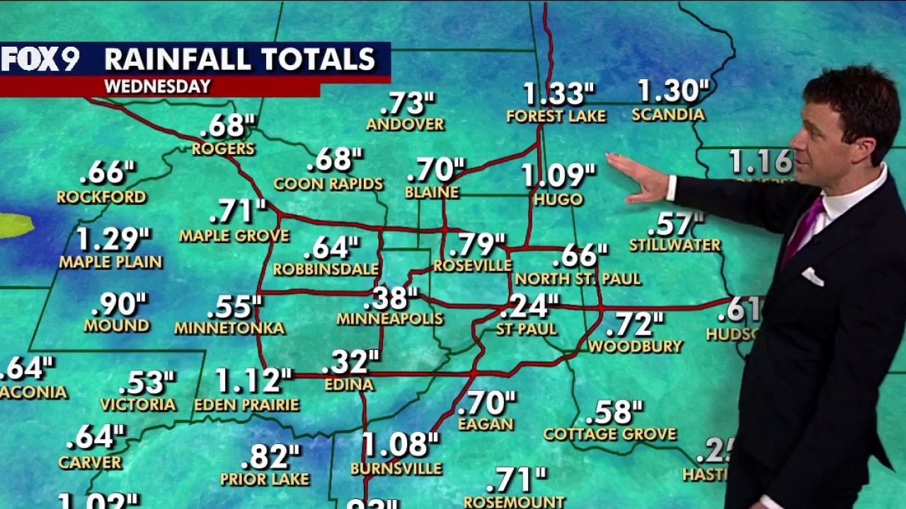
Twin Cities metro rainfall totals

Twin Cities metro area rainfall totals for Wednesday, June 17, 2026. (FOX 9)
Here’s a look at rainfall totals around the Twin Cities metro area.
- Forest Lake: 1.33 inches
- Scandia: 1.30 inches
- Maple Plain: 1.29 inches
- Somerset: 1.16 inches
- Eden Prairie: 1.12 inches
- Hugo: 1.09 inches
- Burnsville: 1.08 inches
- Jordan: 1.02 inches
- Lakeville: 0.93 inches
- Mound: 0.90 inches
- Prior Lake: 0.82 inches
- Roseville: 0.79 inches
- Andover: 0.73 inches
- Woodbury: 0.72 inches
- Maple Grove: 0.71 inches
- Rosemount: 0.71 inches
- Eagan: 0.70 inches
- Blaine: 0.70 inches
- Rogers: 0.68 inches
- Coon Rapids: 0.68 inches
- North St. Paul: 0.66 inches
- Rockford: 0.66 inches
- Robbinsdale: 0.64 inches
- Waconia: 0.64 inches
- Carver: 0.64 inches
- Hudson: 0.61 inches
- Cottage Grove: 0.58 inches
- Stillwater: 0.57 inches
- Minnetonka: 0.55 inches
- Victoria: 0.53 inches
- River Falls: 0.48 inches
- Minneapolis: 0.38 inches
- Edina: 0.32 inches
- Hastings: 0.25 inches
- St. Paul: 0.24 inches
Drying out Thursday, more rain Friday
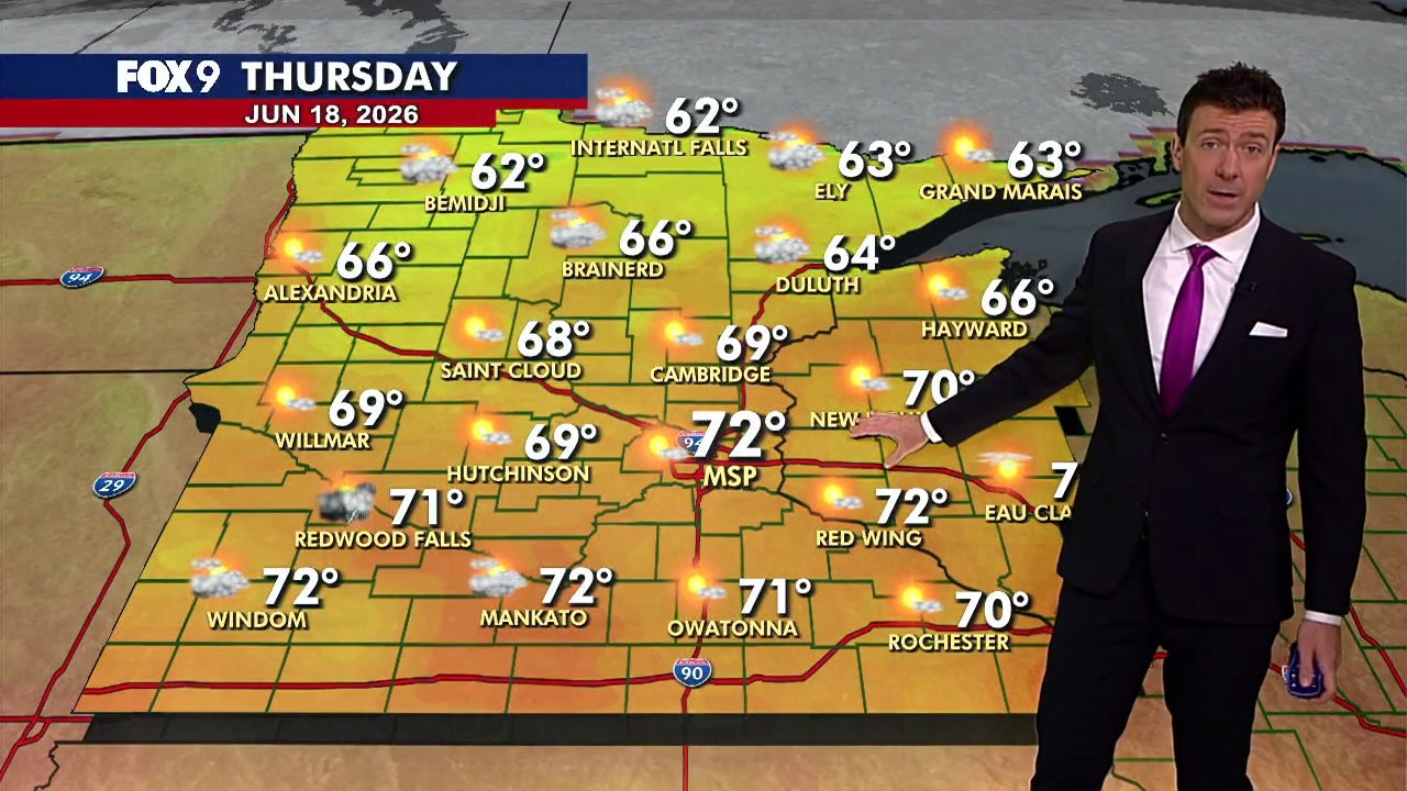
MN weather: Drying out with bright skies Thursday
Minnesota dries out Thursday with sunshine, comfortable temperatures, and highs in the 60s and 70s. A few isolated showers and storms return Friday before a pleasant weekend. FOX 9 meteorologist Cody Matz has the forecast.
The forecast:
Thursday turns much brighter across Minnesota, with sunshine returning after a stretch of unsettled weather.
The Twin Cities metro is expected to top out around 72 degrees, while northern Minnesota remains cooler in the 60s. Winds are out of the northwest at 5 to 15 mph.
Most of the state stays dry, though an isolated shower or thunderstorm cannot be ruled out in southwestern Minnesota during the afternoon.
What’s next:
A weak system moves through Friday, bringing a few scattered showers during the morning hours and isolated thunderstorms in the afternoon. This will be a hit-or-miss setup, and many locations may stay dry. Temperatures remain slightly below average, with highs in the 60s and 70s statewide.
The weekend looks pleasant overall, though a few isolated showers and storms are possible on Sunday.
Here’s a look at the seven-day forecast:

The Source: This story uses information from FOX 9 meteorologists.

